Multispectral imagery (up to 12 bands)
What results can you expect?
Depending on the band configuration of your sensor, i.e. the number of bands and wavelengths, two groups of indices can be calculated:
Structural
Indicators
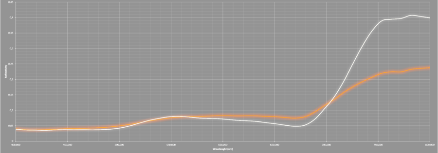
These indices are related to the vigor and structure of vegetation, its growth rates, and its volume and density. They are relevant for the detection of spatial variability in crop growth and areas of low vigor, and typically use information from the near-infrared region combined with the red and green regions. These indices, the best known of which is the NDVI, can be calculated with most cameras available on the market.
Physiological
Indicators
These are more advanced indices associated with the early detection of crop stress using indicators of the physiological status of these crops. Their purpose is to detect water and nutrient deficiencies as well as diseases at an early stage, i.e. before visual identification. They need a more specific band configuration and usually require more than 4 bands covering the near-infrared, red, green and blue regions.
Basic service
Precision Agriculture & Forestry - Multispectral
The basic service focuses on the analysis of structural indicators and includes the generation of the following products using scientifically proven methods
StartAdvanced service
Precision Agriculture & Forestry - Multispectral
In addition to the analysis of structural indicators, it also includes the analysis of physiological indicators and the generation of the following products using scientifically proven methods
StartData required
Geocoded flight images, i.e. images that include information on the x, y and z coordinates of the point of capture. For images that do not include this information, a text file with the coordinates of each image is required.
Radiometric calibration equations (i.e. gain for each channel). If you do not have a calibrated sensor, don’t worry; check out the benefits of subscribing and we will provide the necessary support.
Field measurements for atmospheric correction and conversion of reflectance values. We accept several methods; consult us about the one that you use. If you do not have the necessary field instruments, don’t worry; check out the benefits of subscribing and we will provide the necessary support.
Thermal imagery
What results can you expect?
General service
Precision Agriculture & Forestry - Thermal
This service includes the generation of the following products using scientifically proven methods
StartData required
Geocoded flight images, i.e. images that include information on the x, y and z coordinates of the point of capture. For images that do not include this information, a text file with the coordinates of each image is required.
Radiometric calibration (i.e. blackbody). If you do not have a calibrated sensor, don’t worry; check out the benefits of subscribing and we will provide the necessary support.
Field measurements for temperature correction. If you do not have the necessary field instruments, don’t worry; check out the benefits of subscribing and we will provide the necessary support.
For advanced calculations such as the Crop Water Stress Index (CWSI), please contact us.
Hyperspectral imagery
We are experienced in the processing of hyperspectral data from the main manufacturers (e.g. Headwall Photonics, Cubert), both in the Vis-NIR region and the SWIR region. For this type of advanced processing, please contact us to study your specific case independently.


